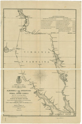
Albemarle and Chesapeake and Dismal Swamp Canals with their connecting waters from 1878-79. These developments facilitated exports from Norfolk.
Source: University of North Carolina.
Since peatlands are almost entirely water by mass and hydrology influences most surface and subsurface processes, drainage has a marked impact on soil moisture. Peat-forming wetlands across the world—including the Southeast—have long been ditched and canalized for timbering, transport, and agriculture, and the peat itself has been mined for fuel and horticultural uses. Along with climate change-induced drought, these actions make peat more susceptible to severe fire. (17)
Proponents of swamp drainage in the Southeast deemed the swamp an uninhabitable, unproductive wasteland, a deficient geography; it was "an unruly environment overlaid with a capitalist (or colonial) spatial imaginary". (18) Colonel William Byrd II, who surveyed the border between Virginia and North Carolina, called the Great Dismal (19) a "miserable morass" of "no value to the crown." (20) Scholar of Black geographies Willie Jamaal Wright offers the term “racialized uneven development” to explain the production of such deficient geographies, which are illegible unless controlled by those in the plantocracy. (21) Yet, for maroons, these spaces were ones of refuge. Not to mention, Indigenous communities took up residence in the swamps upon European settlement and removal efforts. (22)
The first U.S. president, George Washington, (23) organized the Dismal Swamp Land Company in 1763, which put enslaved Black laborers to work ditching the Great Dismal and harvesting pine, gum, cedar, and cypress trees for lumber—with the ultimate goal of draining it for farming. While draining the swamp turned out to be too tall a task, lumbering continued. The Dismal Swamp Canal opened in 1805 to bring the wood to port—an early export from the swamp that lies between the first two English settlements in New England. Drainage wiped out nearly all of the native Atlantic white cedar (Chamaecyparis thyoides), which thrived in the swamp’s peaty soil and was once the most valuable tree in the coastal plain of North Carolina. By 2002, the tree had an acreage of just 5% or less. (24) The nearly 300 years of draining the swamp is thought to be responsible for ~2 Tg of lost carbon. (25)
Aquatic Resolutions
Drainage
This research has (to date) focused on peat-forming swamps of the Southeast with peat that has built up over thousands of years, not fully decomposing as a result of waterlogged conditions. These ecologies dot the Atlantic Coastal Plain from Virginia to Florida. Colonists arriving from Europe struggled to navigate and codify them while Black and Indigenous people inhabited, hid away, and passed through them—just beyond of the sphere of exploitation, disenfranchisement, and dislocation that colonization induced. From the 17th up to the 20th century, the liminality of the swamp provided cover and refuge for those whose labor and lands were under control of the plantocracy.
MORE
MORE
Similarly, in 1856, the State of Georgia commissioned Colonel R. L. Hunter’s survey of the Okefenokee for development, and in 1891, granted 235,000 acres of the swamp to the Suwanee Canal Company to drain. (26) The company began work on a canal between the swamp and St. Mary’s River that they never finished due to economic and engineering issues, though a ditch was cut and other canals built. The company, along with subsequent generations of companies operating in the swamp, used this infrastructure to remove pine and cypress lumber. The Hebard Cyprus Company removed 423,600,000 board feet of lumber between 1909 and 1927 and another 400,000,000 board feet of lumber were harvested by other companies between 1926 and 1942. (27)
Landowners in northeastern North Carolina, from the Albemarle Swamp Land Company in the 1870s to First Colony Farms in the 1970s, altered peatland—once covering one million hectares of the state’s coastal plain—for harvesting timber and agricultural development, reducing the wetland area to 281,000 hectares by 1980. (28) In the 1980s, interest in peat and domestic energy resources lead to the creation of the government-funded United States Synfuels Corporation, which granted upwards of $500 million to subsidize the “First Colony” peat-methanol conversion project in North Carolina—a wasted effort since they found the peat to be unsuitable upon ditching. (29) Peat mining also occurred between the 1930s and 1960s in the Okefenokee. (30)
Now, an application to mine heavy-mineral sands (HMS) just miles down the road from the Okefenokee (and Cherokee of Georgia tribal grounds) threatens to draw down the water levels in the swamp, a continuation of this history of altering the wetness of Southeastern swamps. The application sits on the desks of lawmakers, its fate not yet decided at the time of writing.
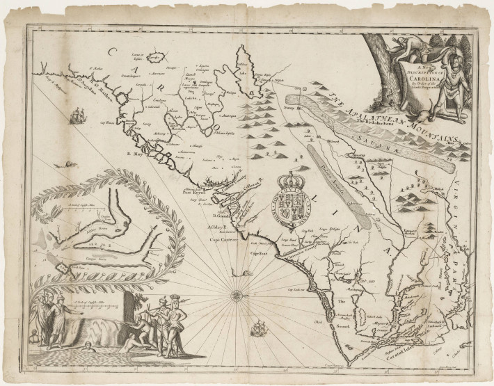
‘A new discription [sic] of Carolina by the order of the Lords Proprietors‘
Source: North Carolina Maps
'Along the borders of the Dismal Swamp Canal'
Source: John Boyle O’Reilly, Athletics and Manly Sport (1890)
Long and well documented is the Great Dismal Swamp (hereafter the Great Dismal), which formed when the Continental Shelf made its last shift about 10,000 years ago, located on ancestral Weapemeoc land at the border of what is now Virginia and North Carolina. It is now part National Wildlife Refuge, part State Park—across a total of 128,000 protected acres—, with tens of thousands of acres of recognized inflowing watersheds. In 1728, Colonel William Byrd II chronicled his survey exploration to establish the border between Virginia and North Carolina, including the Great Dismal, remarking, "Without taking the exact level of the Dismal, we may be sure that it declines towards the places where the several rivers take their rise, in order to carrying off the constant supplies of water." (m) He describes the three rivers rising out of it as hiding their heads, "there being no signs of them above ground," and imagines "plentiful subterranean stores of water to feed so many rivers." (n)
Another of the country’s great swamps, the Okefenokee Swamp (hereafter the Okefenokee) sits on ancestral Creek land at the border between what is now Georgia and Florida. Like the Great Dismal, it is a depression where the bottom of the sea used to be; the Suffolk Scarp that borders the Great Dismal and Trail Ridge on the edge of the Okefenokee mark the shoreline some thousands and millions of years ago, respectively. A 354,000-acre area of the Okefenokee is designated a National Wildlife Refuge, but it is thought to be 700 square miles in total. William Bartram, a naturalist who in the 18th century traveled through the Southern territories of "the Muscogulges, or Creek Confederacy, and the Country of the Chactaws," described it as a "vast accumulation of waters." (o) In 1850, a member of a surveying team wrote, "Standing still a few minutes causes the water to ooze through the moss and make puddles at each foot—evidently a hydraulic bed that no art can imitate." (p)
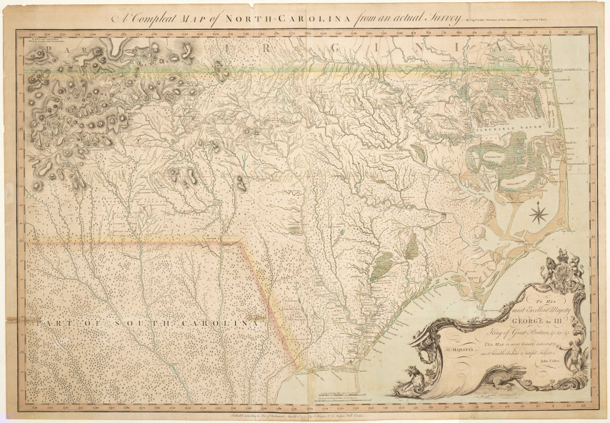
'A Compleat map of North Carolina from an actual survey'
Source: North Carolina Maps
Despite efforts by European settlers at evaluating the swamps, the scope
of these ecosystems of "ubiquitous wetness" (q) escaped calculation and
individuation. The map "A new discription [sic] of Carolina by the order of
the Lords Proprietors" from circa 1671 depicts the Great Dismal about the
same size as Roanoke Island (the first attempted English settlement in the
so-called New World, which, for context, is 18 square miles). (r) The website
for the Great Dismal Swamp National Wildlife Refuge states it once covered
more than a million acres, (s) matching a traveler’s account from 1817. (t) Yet,
numerous conflicting estimates prompted a statement in Harper’s Monthly
from 1856: "It would be difficult to define accurately the limits of the Great
Dismal Swamp...Its area has been estimated at from six hundred to a thou-
sand square miles [384,000 acres to 640,000 acres]." (t) The 1747 "Map of
North and South Carolina and Georgia" simply reads "Full of Swamps" in the
vicinity of the Okefenokee. (u) In another map drawn in 1805, "Okefenoke [sic]
Swamp" and "extent not known" are inscribed alongside "THE CREEK INDI-
ANS." (v)
The name Okefenokee descends from a Creek word with the root Fin-o-cau meaning "quivering," a reference to ground that does not stand still. (w) With sinking and rising batteries (masses of peat), the Okefenokee has been described as "an inland sea with numerous islands," (x) a rendering similar to those of the Great Dismal: "a Considerable tract of land buried under water," (y) its timber "prostrate, and melting, as it were, into the semi-liquid earth." (z) In the Great Dismal, islands known as hummocks are the only reliably dry spots, creating a few feet of relief in the peat surface. Colonial subjects and travelers became submerged in these spaces of indeterminacy and could not "gain ground firm enough" to support a conviction of separateness from nature. (aa) A German visitor to the Great Dismal reflected that "whoever slipped his footing, sank up to the neck in water and deep, fat mire." (ab) While carrying chains to demarcate the Okefenokee, surveyors plunged "knee-deep among the roots and hard torturous stems." (ac)
The swamps compromised the order and outcome of colonial efforts; armies and cartographers alike found themselves "lost, sunk, and sick," in the words of scholar of colonial ecologies Monique Allewaert. (ad) Intellectuals and naturalists examined the effects of the entanglements of the plantation zone on Anglo-European bodies and psyches; their submergence in this new climate, a climate not yet shaped by their ventures, was disorienting and disturbing. It confounded the conception of man as discrete and controlling of nature as well as the notion of nature as separable into water and land, which architect and planner Dilip da Cunha calls "one of the most fundamental and enduring acts in the understanding and design of human habitation." (ae)
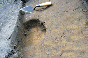
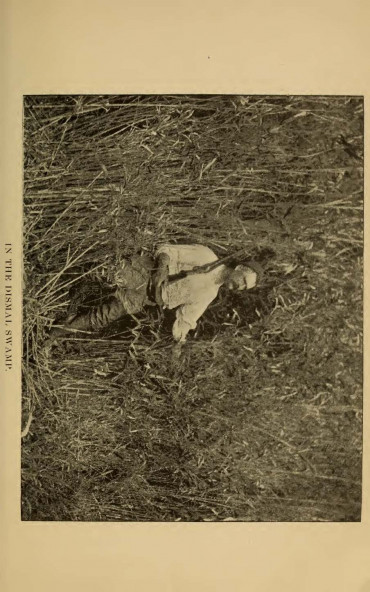
'A posthole, perhaps part of a maroon cabin, lined with pieces of pottery from Indigenous inhabitants for stability.
Source: Marion Blackburn
George Washington’s Ditch in 1927.
Source: State Archives of North Carolina
The dangers chronicled in settler accounts of expeditions and explorations of Southeastern swamps not only derived from the groundlessness of their form, which threatened settler conceptions of self and bodily integrity, but also their function as refuges. White renegades, displaced indigenous people, and fugitives to enslavement (called "maroons") were submerged as they escaped, created, and defended new worlds just beyond the grasp of settlement and enslavement in the borderlands of the plantation zone. Maroon comes from the Spanish cimarrón, itself derived from an Amerindian root. First used in Hispaniola for feral cattle, the term was subsequently applied to Africans who escaped slavery, making it a "derivative of racist attempts to dehumanize insubordinate non-Europeans." (af)
At the same time as it was full of poisonous insects, venomous snakes, and roots and vines that could wound and trap, the geographic conditions of swamps were suited for hiding out. The Great Dismal harbored a "city of refuge in the midst of Slavery," (ag) a "headquarters for organizing networks of resistance." (ah) The Great Dismal was in fact known as the "only place where a death from disease has never occurred," (ai) its waters amber in color and anti-bacterial from tannic acid resulting from the leaching of juniper and cypress leaves. With access to this freshwater and pockets of dry land, maroons cultivated crops and hunted to nourish themselves. The silence and violence of the very one-sided archive of this time period limit a thorough understanding of marronage, but historian Marcus P. Nevius’ compilation of primary sources like abolitionist pamphlets and slave narratives in City of Refuge and archaeological discoveries from the likes of Daniel Sayers foreground resistance in the spirit of what African American studies scholar Saidiya Hartman deems to "brush history against the grain." (aj)
Efforts to subjugate and expel Indigenous tribes and enslave Black people persisted with the growth of the colonies, literally shrinking the space for marronage. Marronage was such a force of resistance to slavery that militias and patrols responded by imposing curfews and violently tracking escapees. (ak) The swamps were racialized in the settler imagination, illegible in their uncontrollability. In "The Morphology of Marronage," Willie Jamaal Wright puts into conversation literature on marronage and society’s relationship to nature to investigate such geographies of "logistical, environmental, and embodied deficiencies;" (al) devalued, unruly landscapes are obliged into a system of "value-coding," (am) their characteristics taking on those of the people associated with them, an idea that can be traced to Enlightenment theories that "properties of the matter that composed a place shaped the persons in that place." (an)
Settlers imported a racial regime of ownership that measured value according to English agrarian capitalist ideas of land. In the words of scholar Brenna Bhandar, "The imperative to quantify and measure value created an ideological juggernaut that defined people and land as unproductive in relation to agricultural production and deemed them waste and in need of improvement." (ao) The swamp was specifically imbued with a wildness that "threatened subversion in its function as well as in its essence." (ap) The combined irregularity of the swamp’s ecology and the fear installed through racializing the landscape made the swamps into wastelands that needed to be drained in order to be productive in the colonial framework.
Colonel William Byrd II, who surveyed the border between Virginia and North Carolina, was the first proponent of a drained Great Dismal, calling it "a nuisance" of "no value to the crown" in his "Description of the Dismal, with the Proposal to drain it," written sometime between 1728 and 1737. (aq) In 1763, America’s first president, George Washington, and others formed the Adventurers to Drain the Great Dismal Swamp, paving the way for support from the Virginia government toward the formation of the Dismal Swamp Canal Company. The first cut into the land was Washington’s Ditch, running from the settlement called Dismal Town five miles to the Great Dismal’s Lake Drummond. Washington lived at Dismal Plantation in Dismal Town but his brother, John Augustine Washington, was its overseer who put fifty-four enslaved people to work:
The enslaved laborers cleared a sector of old cypress and cedar trees and younger red and white oaks, maples, and elms and dug an irrigation ditch the oldest white cedar trees into more than ten thousand eighteen-inch shingles, which became the extracted natural resources that provided the earliest of the [Dismal Swamp Canal Company’s] profits. (ar)
The shingles were not only the earliest units of production of the Dismal Swamp Canal Company but also some of the first exports from the colonies. Agricultural development turned out not to be lucrative but the Dismal Swamp Canal was constructed, connecting economically important parts of the region. Four years after the canal’s completion, the soil in Great Dismal had reportedly "shrunk" 0.3 m (12 in). (as)
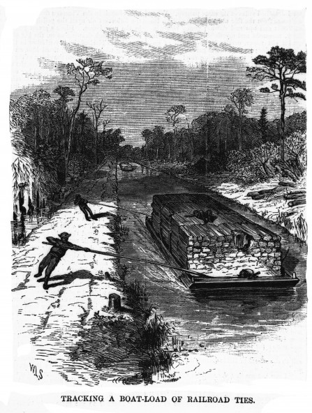
Tracking a boat-load of railroad ties
Source: Library of Congress
'Along the borders of the Dismal Swamp Canal'
Source: John Boyle O’Reilly, Athletics and Manly Sport (1890)
The narrative around the Great Dismal bears resemblance to that of the
Okefenokee, which geographer Sidney E. Morse called "uninhabitable by
any human being" in 1822. (at) The preface to settler W. W. Starke’s 1851 article on drainage in the area reads: "Major STARKE deserves the thanks of the public...for having transformed a prolific source of pestilence—worse than
a barren waste—into a salubrious and most productive plantation. There
are thousands of acres in the southern Atlantic States now worthless which
are equally susceptible of reclamation by proper drainage." (au) The Florida
Armed Occupation Act of 1842 went as far as providing free land to settlers
willing to inhabit and defend the Okefenokee hinterlands while legislation
promoted the drainage of swamplands on a federal level.
Just as settler-colonial ideas of property ‘turned on the relation between
person and thing’, so did the survey dissociate space and property from
sociality, making a world based on life as set against an inert structure. (av) In
the Southeast, the legacy (or ancestral present) of establishing the land-
scape as inert manifests as fire—fire that is increasingly frequent and severe, smouldering for months, instigated by centuries of damage to the peat aggravated by climate change-induced drought.
For the complete version of this research, download the PDF >>
West Mims
Accumulation
Drainage
Extraction
Connectivity
Refugia